So, it is mid May now, and I am almost half way done with the May challenge. I'm on track! And this past Sunday I and my cohort completed our first volcano summit. Our adventure is as follows:
Balls! After mentioning on facebook my idea of climbing all of California's volcanoes, only one person said she was totally down with doing it with me. Crazy, I know, only one. I asked if she was serious, and low and behold, she was. She is fascinated by profanity and uses the word balls as a swear word. Although her favorite word at the moment is dick, I will stick to calling her Balls. Balls lives in Santa Rosa. For those of you not from California, it is north of San Francisco by about 55 miles. While researching which volcano to do first, I decided we'd best go for the closest one first. That happens to be Mount Konocti on the shore of Clear Lake in Lake County.
 | |
| Red Arrow=where I live, Blue Arrow=where Balls lives, Black Arrow=Clear Lake/Mt. Konocti |
I drove up to Balls' house Saturday night, forgot my phone, left it charging in the wall, and slept on Balls' couch. Woke up with her roommates dogs face in my face. Sunday morning we drink coffee. Coffee is important. We go to Whole Foods for snacks, and then leave for Kelseyville, where Mt. Konocti awaits us. We drive into town and turn down a road that turns to dirt. There is no signage telling you that there is a county park at the end of the road, let alone a freaking VOLCANO! Lake County is severely lacking on proper signage. This you will note is a frequent subject while Balls and I were on the trail. Balls was also somewhat shocked that I had an actual camera. Even if I hadn't forgotten my phone, it isn't a "smart" phone. So yes, I'm old school and carry an actual camera.
 |
| Look, we can take double selfies at the same time. We are awesome. |
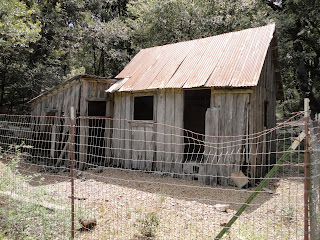
We finally made it to Mary Downen's cabin. Who? And why did she build a homestead on the side of a volcano? Well, once again, the signage wasn't great here. Apparently in 1903, a year after her husband died, her son-in-law Euvelle Howard (as in Howard Peak) took her up Mount Konocti on horseback and she fell in love... with the mountain. She staked a claim and paid a whooping $600. A cabin was built and she began homesteading... alone. There is no streams on the mountain and eventually she had a cistern built and her son-in-law Euvelle planted her orchard. Apparently her son-in-law moved up there. Balls and I debated why her daughter didn't move with him and talked endlessly about them most likely having an affair, but that kind of wigged us out. Ew. Euvelle is apparently buried near the homestead. The crappy signs say he is buried 500 ft from the cabin with a large "obvious" boulder with his name and dates carved in it. They even provide waypoints. But there is no path. So we plug in the waypoints into my pilfered gps and off I go uphill, off trail, looking for the "obvious" boulder. I never found him. Why the hell tell people he's up here and all and then not provide a way to actually get to him?? I don't get it. And why is he buried here and not Mary? What ever happened to her? We have no idea. We had to look her up on the internet during dinner. Found where she is buried. She's in Lakeport and shares her husbands marker. So she was buried on top of him, or next to him. I don't know. There is hardly anything about Mary on the internet. It's all the same little bit on every site we could find. She seemed like a very interesting person. Who decides to homestead on a volcano as a widower in her 50's in 1903? She sounds awesome. I want to know what happened to her. How long was she on the mountain? Where's her privy? How did she die? There is nothing! Now, there is obviously some archaeological records out there on her homestead. They fenced off her cabin and dump and there are pin flags everywhere. So those of you who still have access to CHRIS can maybe help a girl out?? Yes?
 |
| Mary Downen's Orchard |
We made it to the summit of Wright Peak! Great views. Top of the world... or Lake County anyway. While I was taking this pic of Balls, she took this one.
There is a fire lookout and cell tower on the top. The fire lookout was closed in 2005, technology and all that made it useless to stick a person up there 24/7 during fire season. There are some interesting stories about this mountain/volcano but I will spare you. I will say that I'm impressed that the Pomo name for the mountain remains. As with most of the history of white settlers, army, and Indians, things did not go well for the Pomo and Wapo that call this area home.
 |
| Clear Lake from Wright Peak |
 |
| View of Howard Peak from Wright Peak |
 |
| Balls' best Capt. Morgan pose |
Our experience of Mt. Konocti has only wetted our appetite for more volcanoes, despite us being in Lake County and their lack of trail signage. We realized that both of us have forgotten much of our botany skills and need to brush up on them, not that we had any to begin with. And we need to do more pre-field research and learning before our next volcanic adventure. So 1 down, 19 to go.


1 comment:
Awesome.
Post a Comment